Most new developments include landscape works. Landscaping enhances and protects the character and function of a site and its surroundings.
Landscaping on both public and private land aims to:
- support the overall aims and objectives of the Toowoomba Regional Planning Scheme.
- ensure landscape design considerations are incorporated early in the planning and design stages of development, integrating landscape outcomes into overall site design
- reduce negative visual impacts of development on neighbours
- minimise maintenance needs and reduce safety risks associated with public and private developments
- encourage environmentally sensitive design practices, including water and energy efficiency, by incorporating seasonal considerations, sustainable materials and appropriate plant species for the local soil type and microclimate
- protect the character and function of the site and surrounding area
- promote a strong sense of place consistent with existing character
- provide a robust, long-lasting landscape that remains healthy for the life of the development.
We advocate for integrating landscape outcomes into the overall site design. This ensures that landscape works satisfy the Planning Scheme policies and the code at part 9.4.4 of the Planning Scheme.
We assess proposed developments under the Planning Act 2016 (Qld). The Planning Act provides two methods for assessing and approving landscape proposals associated with development:
- Material Change of Use (MCU) or Reconfiguring a Lot (RAL) assessment
- Landscape endorsement.
MCU or RAL assessment
You may include a site analysis and landscape concept plan in an application for either:
- a Material Change of Use
- a subdivision that will create a new road.
We may approve a sufficiently detailed and properly prepared site analysis and landscape concept plans as part of the development permit. In this case, you do not need to also apply for a Landscape Endorsement Certificate.
Landscape plan endorsement
If your application does not include a landscape plan, we may add a condition to your approval that requires you to submit one for a Landscape Endorsement Certificate. To do this, you must:
- Complete the Endorsement of plans and document request.
- Submit detailed landscape plans and documents.
- Pay the applicable fee.
Our process includes:
- reviewing plans against the Planning Scheme and relevant codes
- issuing a Landscaping Further Advice Notice if we need extra information
- issuing a Landscape Endorsement Certificate if you satisfy the review process and relevant conditions.
Our preferred outcomes for any landscape work are that:
- development provides landscaping that protects and enhances amenity and creates a sense of place consistent with the preferred local character
- landscape design protects and enhances the area's natural environmental values from the adverse impacts of development
- landscape design suits local soil and climatic conditions and is robust to ensure the development's longevity and health
- landscape design optimises water and energy efficiency by designing for seasonal change, selecting sustainable materials and choosing plant species suited to the local microclimate.
Specific performance outcomes appear in the Planning Scheme's codes and policies.
All plans must be:
- drawn to scale and include a scale bar.
- legible when printed at A3.
- formatted in a PDF file.
The title block must include the:
- title
- property address
- date
- plan identification number
- version and amendment table
- name and contact details of the designer
- related MCU or RAL application or permit number.
The north block:
- must include a north point
- should be oriented with north at the top of the page where possible.
Extra requirements
A landscape concept plan or detailed landscape plans must also include:
- tree protection - detail of measures to protect existing trees (including street trees) from damage
- hardscape - dimensions, levels, materials and finishes for all pavements, walls, fences and garden edging
- planting - species, number and location of plants, plant schedule and watering points
- irrigation - extent and type of proposed automatic irrigation
- details and specifications - written and graphical details for all constructed landscape elements.
Learn more about the four styles of landscape plans we accept.
Site analysis
The basis of good design is recognising a site's existing character and context. The site analysis (Diagram 1):
- illustrates the key characteristics of the site and its surroundings
- demonstrates how the design responds to opportunities and constraints.
The site analysis must be prepared on a survey basis, showing the elements below:
- property boundaries, fences and retaining walls
- existing buildings, including those on the immediate neighbouring properties
- contours and drainage lines
- kerb line and all structures and trees within the verge
- existing trees, including species, condition and approximate height
- major overhead or underground services
- images or descriptions of the streetscape and neighbourhood character.
The site analysis must also graphically identify the factors that influence the design proposal.
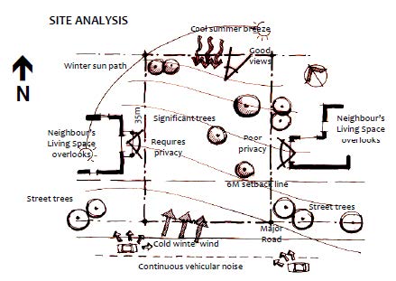
Diagram 1: Example site analysis
Landscape concept plan
This plan style demonstrates how a development's design intent addresses landscaping requirements in the Planning Scheme. But it doesn't meet the requirements for a detailed landscape plan.
A concept plan (Diagram 2) conveys the primary functional and aesthetic elements of the landscape design. It illustrates hard and soft landscape treatments that:
- integrate with and enhance the surroundings
- create an attractive and comfortable environment for occupants.
The landscape concept plan must show:
- existing features – trees, fences, walls and other structures to be retained (including within the verge)
- proposed buildings – wall and eave lines, window and door locations, access, parking and utility areas
- site services – location of underground services, manholes, meters and fire hydrants
- finished surfaces – dimensions and materials for all surfaces and statement of the percent of area that is permeable
- fencing – location, height and colour
- retaining walls – location, height, materials and cross-section where located in the frontage
- planting beds – location, width, edge materials and typical cross-section
- planting – intended function, indicative species and height at maturity, and typical planting detail
- turf – extent of turf or grass seeding (only in areas greater than 1.5m wide)
- drainage – location, finished levels and indicative species of vegetated stormwater structures
- imagery – streetscape elevation and images of intended landscape character.
Diagram 2: Example landscape concept plan
Detailed landscape plan
Use this plan style when you apply for a compliance assessment as a condition of a DA. This type of plan (Diagram 3) must be prepared by either:
- a qualified landscape architect
- a qualified landscape designer.
The detailed landscape plan must show:
- existing features - trees, fences, walls and other structures to be retained (including within the verge)
- existing and proposed buildings - wall and eave lines, window and door locations, access, parking and utility areas
- site services - location of underground services, manholes, meters and fire hydrants
- surface finishes - dimensions, finishes and materials for all surfaces and statement of the percent of area that is permeable
- levels - for all pavements, walls, fences and garden edging
- fencing - location, height and colour
- retaining walls - location, height, materials and cross-section where located in the frontage
- planting beds - location, width, edge materials and typical cross-section
- planting - intended function, indicative species and height at maturity, and typical planting detail
- plant species - details of species, number and container size
- turf - extent of turf or grass seeding (only in areas greater than 1.5m wide)
- drainage - location, finished levels and indicative species of vegetated stormwater structures
- construction details - edging, garden preparation, planting and mulching
- irrigation - proposed automatic irrigation or location of watering points
- calculations - percentage of permeable landscape area, and percentage of shade to hard surfaces within five years of completion
- maintenance - establishment and maintenance schedule.
Diagram 3. Detailed landscape plan example
Street tree plan
Use this plan style (Diagram 4) when you need to include planting details for street trees on Council verges.
Prepare the plan in line with PSP No. 2 Engineering Standards and include:
The landscape concept plan must show:
- existing features – trees, fences, walls and other structures to be retained (including within the verge)
- existing and proposed buildings – wall and eave lines, window and door locations, access, parking and utility areas
- site services – location of underground services, manholes, meters and fire hydrants
- typical street cross-section – dimensioned to indicate tree clearance from underground services, footpaths and light poles
- planting locations and detail – minimum 2m wide by 1m deep planting space, soil preparation, fertiliser, mulch, staking
- plant schedule – species, number and location of plants, and street trees to be supplied in 45L containers
- turf – extent of turf or grass seeding (only in areas greater than 1.5m wide)
- fencing – location, height and colour
- retaining walls – location, height, materials and colour
- drainage – location, finished levels and indicative species of vegetated stormwater structures
- establishment maintenance schedule – based on 12 months of maintenance by the developer before we can accept suitable-standard street trees.
Diagram 4. Street tree plan example