Toowoomba Region Trails Network Strategy 2016
The Toowoomba Region Trails Network Strategy 2016 (TRTNS) has been developed following detailed community consultation, investigation and auditing of the existing trails network, review of current gaps and identification of future demands and opportunities. The TRTNS provides a framework for the future strategic direction and development of recreation trails across the Toowoomba region and will ensure a consistent approach to planning, managing and implementing a network of recreation trails. The TRTNS is a series of key documents encompassing Volume 1 – The Strategy, Volume II – Background information, Volume III – Existing Trails Audit, Volume IV – Consultation.
The Strategy (Volume I) includes an overview of a 5 year implementation plan to enhance the region’s recreational trails. It details desired key outcomes for the trails network and highlights the detailed strategies required to achieve the desired outcomes. Short, medium and long term strategies and actions are identified and reviewed.
The other supporting volumes of the Strategy are available by request.
Project outcomes and intent
Toowoomba Regional Council (TRC) engaged Tredwell Management Services to develop a Toowoomba Region Trails Network Strategy to investigate, audit and provide a framework for the future strategic direction of trails across the Toowoomba region.
The Strategy provides a clear and comprehensive plan for the establishment of an integrated network of trails that promotes the use and values of quality and connected infrastructure. The establishment and improvements of the trails network will respect key values of environment and heritage.
As an outcome of the Strategy, Council will have a trail network that:
- Provides a range of affordable and sustainable experiences and activities suitable for different interests, skill levels and abilities
- Is based on contemporary recreation planning and trends
- Is well planned, developed and managed, ensuring environmental and heritage values are protected
- Helps create an informed and educated community
- Has links to neighbouring local governments, resource entities and the Queensland Government’s managed natural resource areas
- Fits into a regional network of outdoor recreation opportunities
- Meets Council’s land and trail management access requirements.
More information including the detail of this strategy, please refer to the Toowoomba Region Trails Network Strategy 2016 - Volume 1 - The Strategy(PDF, 6MB) in 'related documents' area below.
Strategy and action plan highlights
Included here are some extracts from page 55 of Volume 1.
10.4 Key trail activity areas
The following strategic approach to the delivery of a trails network across the region is proposed, principally based around recognising existing areas that offer a significant number of existing trails, are known areas of significant trail use or areas of significant future growth that will require additional trail provision. The Key Trail Activity Areas are:
- Toowoomba / Escarpment Parks - Regional Trails Hub
- Westbrook & Surrounds
- Highfields & Surrounds
- Crows Nest & Surrounds
- Yarraman & Surrounds
- Primary Equestrian Activity Zone
11.5 Strategic Outcome A: Existing Trails Network
Strategy A1 Key Trails & trail activity areas
Extract from page 63...
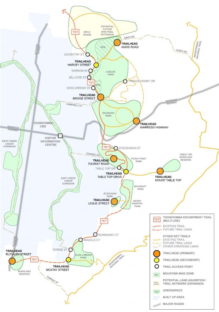
Strategy A1: Focus available resources at key existing trails and identified Key Trail Activity Areas (refer Figure 14), including the Bicentennial National Trail (national-level trail) and Brisbane Valley Rail Trail (regional-level trail).
Rationale: In the shorter term, trail development focuses on the Key Trail Activity Areas, enhancing linkages between existing trails within these areas and the key existing trails of the Bicentennial National Trail and the Brisbane Valley Rail Trail
Priority: HIGH
Strategy A2 Jubilee Park
Extract from page 65...
Strategy A2: Enhance and develop the existing trails and support infrastructure within Jubilee Park, and promote as an integral part of a wider trail network
Rationale: Jubilee Park currently offers a range of trail experiences including multi-use trails and the region’s only recognised network of single track mountain bike trails. Additional trail infrastructure is required to service the current users of this park, including upgraded facilities at Bridge Street, which will also service users of Redwood Park, and potentially any new use for the quarry site. The re-naming and assigning/identification of a purpose for individual trails, plus the installation of additional interpretation will assist in clarifying the nature of the trails within Jubilee Park. The mountain bike trail network crosses other trails at multiple locations and it recommended that additional signage is installed at key location to highlight these locations.
Priority: MEDIUM
Strategy A3 Redwood Park
Extract from page 63...
Strategy A3: Enhance and develop the existing trails and support infrastructure within Redwood Park, and promote as an integral part of a wider trail network.
Rationale: Improving connectivity to and circulation around Redwood Park will build on the successes of recently completed projects around the trailhead adjacent to Warrego Highway, including infrastructure upgrades and the Rainforest Circuit. The challenging terrain of Redwood Parks means that relatively few people would likely tackle many of the longer trail loops that are currently available; the reinstatement of Fern Tree Gully Circuit would provide a shorter but still challenging loop trail experience.
Priority: MEDIUM
Strategy A4 Picnic Point Park
Extract from page 67...
Strategy A4: Enhance and develop the existing trails and support infrastructure within Picnic Point Park, and promote as an integral part of a wider trail network.
Rationale: Picnic Point Park is a key attraction and destination within the region, offering excellent facilities, access to the escarpment and stunning views over Mount Table Top and the surrounding landscape. As such, trail infrastructure should be progressively upgraded and maintained to high standards. As with the other escarpment parks, improving connectivity within and into the park will be a priority.
Priority: MEDIUM
Strategy A5 JE Duggan Park
Extract from page 69...
Strategy A5: Enhance and develop the existing trails and support infrastructure within JE Duggan Park, and promote as an integral part of a wider trail network.
Rationale: JE Duggan Park benefits from several short walks around a relatively small area of notable environmental value. Of note are localised areas of relatively flat land (rare within the escarpment parks network) that offer the potential to establish trails with universal access, and provide accessibility for all trail users. This trail network is currently isolated from the other trails networks along the escarpment and would benefit from upgraded infrastructure.
Priority: HIGH
Strategy A6 Glen Lomond Park
Extract from page 70...
Strategy A6: Enhance and develop the existing trails and support infrastructure within Glen Lomond Park, and promote as an integral part of a wider trail network.
Rationale: Hell Hole Track is a well-known destination within the local community, with a large grassed clearing at the end of the track. However existing trail signage is confusing in terms defining overall distance, and the ultimate destination is far from clear on the ground, with a second track leading off from the grassed clearing and continuing downhill. This second track eventually to end halfway down the escarpment, with no clear route through, although it is understood that locals are aware of an informal route that leads down to Upper Flagstaff Creek Road.
Priority: MEDIUM
Strategy A7 Mount Table Top
Extract from page 71...
Strategy A7: Clarify Mount Table Top as a site of significance to the local Aboriginal communities, by providing sufficient information for visitors to make informed and respectful choices regarding accessing the summit of Mount Table Top and completing the Mount Table Top Walk; and based on the condition/standard of the track.
Rationale: Mount Table Top is an important site for the local Aboriginal community. As an area of cultural significance it is recognised in the Aboriginal Cultural Heritage Register and is protected under the Aboriginal Cultural Heritage Act 2003. There is the view by many, that climbing to the summit is not to be encouraged. At the same time, Mount Table Top is also well-known feature of the region and popular with the local community and visitors to the region. Currently the informal track is not actively promoted, nor managed/ maintained by Council, resulting in potential safety concerns for those who do climb to the summit. Future discussions must involve the local Aboriginal communities and will be informed/ guided by the existing Indigenous Land Use Agreement (ILUA).
Priority: HIGH
Strategy A8 Mount Peel
Extract from page 72...
Strategy A8: Building on the existing trails network at Mount Peel continue to develop the reserve as a destination for walking, horse riding and mountain biking (beginner level)
Rationale: Mount Peel Bushland Reserve currently has a network of clearly defined trails / firebreaks that is used by walkers, horse riders and, to a lesser extent, mountain bikers. Proximity to the growing residential population at Westbrook means that there will be increasing pressures for recreational use of the Reserve (both authorised and unauthorised). Additional trail infrastructure is recommended to improve accessibility and navigation around the Reserve, as well as addressing unauthorised use of the reserve.
Priority: HIGH
Strategy A9 Cranley Escarpment Park
Extract from page 73...
Strategy A9: Investigate the potential to develop and formalise the existing informal trails and firebreaks network
Rationale: At the time of the development of this Strategy and the undertaking of the existing trail audit Cranley Escarpment Park was inaccessible, with temporary barriers in place at the main access points to the park. However, it is understood, through on-ground observations and the consultation process, that there exists a network of informal trails and firebreaks used by the local community. The nature of these informal trails, together with the challenging terrain and degraded environmental values of the park require careful consideration to deliver a network of sustainable trails.
Priority: MEDIUM
Strategy A10 Highfields Falls
Extract from page 74...
Strategy A10: Continue to develop Highfields Falls as a bushland reserve destination for locals and visitors to the region
Rationale: Highfields Falls provides a natural bushland setting in close proximity to Highfields. There is significant potential to improve wayfinding and interpretation and the overall trail experience through additional trail infrastructure. There are also opportunities to promote Highfields Falls to visitors to the region as a short walk destination.
Priority: MEDIUM
Strategy A11 Crows Nest
Extract from page 75...
Strategy A11: Continue to develop and build upon the existing trails network in Crows Nest, incorporating Bullocky’s Rest, Applegum Walk and Hartmann Park
Rationale: There has previously been investment in upgrading Bullocky’s Rest as a stopping point for visitors to the town, with links into the adjoining Hartmann Park via Applegum Walk. Additional trailhead and wayfinding is required to promote the existence of these trails to visitors and clarify the trail alignments/distances/grade on the ground.
Priority: MEDIUM
Strategy A12 Lake Cressbrook
Extract from page 76...
Strategy A12: Enhance and develop sustainably located and designed existing trails at Lake Cressbrook, including development of additional infrastructure.
Rationale: Lake Cressbrook currently includes significant infrastructure suitable to support land and water based trail activities including campground, toilet/shower amenities, boat ramp and wayfinding signage. A priority is to improve navigation around the inlet and connect the main car park with the campground and the lakeside trails. Future opportunities might include investigation of extending the lakeside trail further around the lake, in collaboration with Somerset Regional Council.
Priority: MEDIUM
Strategy A13 Lake Perseverance
Extract from page 77...
Strategy A13: Maintain sustainably located and designed existing trails at Lake Perseverance.
Rationale: There is currently limited trail infrastructure accessible to general public around Lake Perseverance with the exception of the lookout, which involves a short walk through a picnic area up to an elevated lookout point.
Priority: LOW
Strategy A14 Lake Cooby
Extract from page 78...
Strategy A14: Enhance and develop sustainably located and designed existing trails at Lake Cooby, including development of additional infrastructure.
Rationale: Lake Cooby includes significant infrastructure suitable to support land and water based trail activities including car parking, toilet amenities, boat ramp and wayfinding signage. There is an 8km return walk trail adjacent to the lake, however, trail information on the ground is limited, poorly located and inconsistent. In addition, part way along the trail the alignment becomes unclear/unpassable, with limited wayfinding signage to confirm the route between the main car park and the dam wall.
Priority: MEDIUM / LOW
Strategy A15 Yarraman
Extract from page 79...
Strategy A15: Enhance connectivity between Yarraman town centre, the sports reserve, Heritage Centre and Station Park to promote the existing formal and informal trail network
Rationale: Connectivity between the town centre and the existing formal and informal trailheads is currently limited due to an absence of appropriately located signage.
Priority: MEDIUM
Strategy A16 Munro Tramway
Extract from page 80...
Strategy A16: Continue to support the Munro Tramway Historical Group to implement current upgrade projects and consider future enhancements to the existing trail
Rationale: Munro’s Tramway is a significant historic route for the Toowoomba region, which joins the localities of Palmtree and Hampton. The tramway was a private investment from the Munro Family in the late nineteenth century to transport produce from their flourishing timber sawmill at Palmtree to the main railway at Hampton. In 2015 the Munro Tramway Historical Group Inc. was formed to support the development of this route as a walking track with interpretive signage. The alignment of the tramway is on a combination of private land and road reserve.
Priority: MEDIUM
Strategy A17 Other existing trails (including Muntapa Tunnel, Mt Kingsthorpe, Mt Basalt, Prime Ministers Walk, Panoramic Walk, Williams Park and the Charles and Mottee Rogers Nature Trail)
Extract from page 81...
Strategy A17: Continue to maintain other existing trails around the region, and upgrade in line with the actions detailed below, with projects prioritised where there is demonstrated community support, and where Council resources are available.
Rationale: There are a number of other trails across the region that would benefit from the address of current management/maintenance issues, additional trail infrastructure or upgrade of trail tread to improve and maximise accessibility.
Priority: MEDIUM / LOW
11.6 Strategic Outcome B: Future Trails Network
From page 82...
- Strategy B1 Trail Corridor Protection Policy
- Strategy B2 Escarpment Parks Trails Network – Enhanced Connectivity
- Strategy B3 Toowoomba Escarpment Trail – Multi-use Trail
- Strategy B4 Mountain Bike Trails Network Development
- Strategy B5 Primary Equestrian Activity Zone
- Strategy B6 Highfields – Escarpment
- Strategy B7 Crows Nest & Surrounds
- Strategy B8 Yarraman & Surrounds
- Strategy B9 Historic Stock Routes / Transport Corridors
- Strategy B10 Other Trail Projects for Local Towns/Communities
- Strategy B11 Vehicle Touring / Drive Trails
11.7 Strategic Outcome C: Promotion, marketing and participation
- Strategy C1 Mapping & Information
- Strategy C2 Promotion & Marketing
11.8 Strategic Outcome D: Trail development, management and maintenance
- Strategy D1 Trail Planning Framework
- Strategy D2 Management Structures
11.9 Strategic Outcome E: Community, tourism and Economic Development opportunities
Implementation plan
Extract from page 102...
Implementation year 2016/17
- Strategy A2: Jubilee Park
A2.7 Install trail user warning signage at key locations where shared -use/multi-use trails are crossed by mountain bike trails
- Strategy A3: Redwood Park
A3.7 Review vehicular access arrangements into Warrego Highway trailhead (Redwood Park) to ensure current layout meets required safety standards
- Strategy A4: Picnic Point Park
A4.2 Investigate opportunities to re-instate the recently removed Bob Dodd Lookout
A4.5 Review/update conflicting information on signage that identifies horse riding as not permissible on the Firebreak (Picnic Point Bridle Trail)
A4.8 Review Warrego Highway crossing (north end of Stevenson St) to ensure that it is safe and suitable for use by walkers, cyclists and horse riders
- Strategy A7: Mount Table Top
A7.1 Undertake a risk assessment of the current ‘informal’ trail that leads to the summit
- Strategy A7: Mount Table Top
A7.2 In consultation with the community, review Council’s current position in relation to access to the summit and advice provided to the local community and visitors to the region (including the VIC official position statement)
- Strategy A10: Highfields Falls
A10.4 Install safety/warning signage at the base and top access/viewing points to the waterfall
- Strategy A14: Lake Cooby
A14.4 Assess the existing bridge along the trail to ensure it remains fit for purpose
- Strategy A16: Munro Tramway
A16.1 Upgrade signage on the trail in line with recent funding received (current project)
A16.2 Work with the Munro Tramway Historical Group to investigate the feasibility of developing a display within Chapman Park (Hampton) comprising one of the Shum locomotive engines recently procured by the group
- Strategy B3: Toowoomba Escarpment Trail – MultiUse trail
B3.1 Undertake a feasibility study to establish the viability of developing the Toowoomba Escarpment Trail, connecting Harvey Street in the north with Bushland Reserve, Ruthven Street in the south
- Strategy B4: Mountain Bike Trails Network Development
B4.1 Establish the viability of further mountain bike trail expansion within Jubilee Park, including tunnel link between Defibrillator and Hyperlink trails
- Strategy C2: Promotion & Marketing
C2.2 Develop a coordinated approach to marketing the trails network through the development of a Trails Marketing Strategy
- Strategy C2: Promotion & Marketing
C2.3 Develop a Toowoomba region trail logo for inclusion on all future trail signage and trail brochures
- Strategy C2: Promotion & Marketing
C2.4 Develop and adopt a style guide for trail signage, facilities and infrastructure
C2.5 Remove dysfunctional, damaged, incorrect and illegible signage and replace with new signage in line with the style guide
C2.6 Develop a website (or webpage hosted by Council) that provides comprehensive details of all trail opportunities within the region, to include interactive mapping and downloadable resources with links to the DNPSR website
- Strategy D1: Trail Planning Framework
D1.3 Formalise mechanisms for inter-Council collaboration to implement mutually beneficial trail development projects for the wider region
D1.4 Encourage, advocate and seek funding for a designated trail planning and development officer
Implementation plan for subsequent years can be found from page 105.
Related documents
For more reading including the following additional volumes, please contact us.
- Volume II - Background information
- Volume III - Existing trails audit
- Volume IV - Consultation